
IBCSO V1.0
The digital bathymetric model (DBM) of IBCSO Version 1.0 has a 500m x 500m resolution based on a Polar Stereographic projection for the area south of 60° S. It is publicly available together with a digital chart for printing.
When using any data from the IBCSO project please cite:
Arndt, J.E., H. W. Schenke, M. Jakobsson, F. Nitsche, G. Buys, B. Goleby, M. Rebesco, F. Bohoyo, J.K. Hong, J. Black, R. Greku, G. Udintsev, F. Barrios, W. Reynoso-Peralta, T. Morishita, R. Wigley, “The International Bathymetric Chart of the Southern Ocean (IBCSO) Version 1.0 – A new bathymetric compilation covering circum-Antarctic waters”, 2013, Geophysical Research Letters, Vol. 40, p. 3111-3117, doi: 10.1002/grl.50413
Database
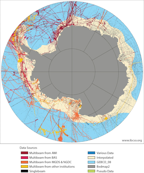
The IBCSO database currently consists of more than 4200 million data points contributed by more than 30 institutions from 15 countries. In total 177 multibeam cruises were available building the nuclei of the database. Single beam echo sounding data, digitized soundings from nautical charts and regional bathymetric compilations are rounding off the database. A list of datasets used for the compilation of IBCSO Version 1.0 can be downloaded here:
An overview of included data sources and the spatial distribution can be seen in the source identification map (above right).
The IBCSO group also tries to improve multibeam data acquisition in the future by providing information about the current multibeam coverage in the Southern Ocean. The IBCSO SID can be used to determine where multibeam data has already been surveyed. For an easier access to this information, we also provide a GIS ready shapefile showing the outline of multibeam surveys as of IBCSO V1.0 here:
Data Contributions
If you are holding bathymetric data that is not yet included in the IBCSO database, we encourage you to contribute this data to improve the IBCSO digital bathymetric model for the benefit of all. Contributed data will be acknowledged and will only be used to generate the IBCSO digital bathymetric model. To contribute data, please contact us.
Cartography data
To enable users to visualize their own data on a map with the IBCSO look and feel, we are offering the base data of the IBCSO printable chart as a georeferenced image. The ‘Background’ maps contain RGB rasterfiles in GeoTiff format, which is compatible with most GIS programs. In addition, we offer the contours of the IBCSO Version 1.0 bed elevation digital bathymetric model in 500 m intervals as Shape files.
2013 – 2021